Perandoria Romake në kulmin e saj (Imperium Romanum) – Hartë e detajuar
[ sguraziu – ars poetica, korrik 21 ]
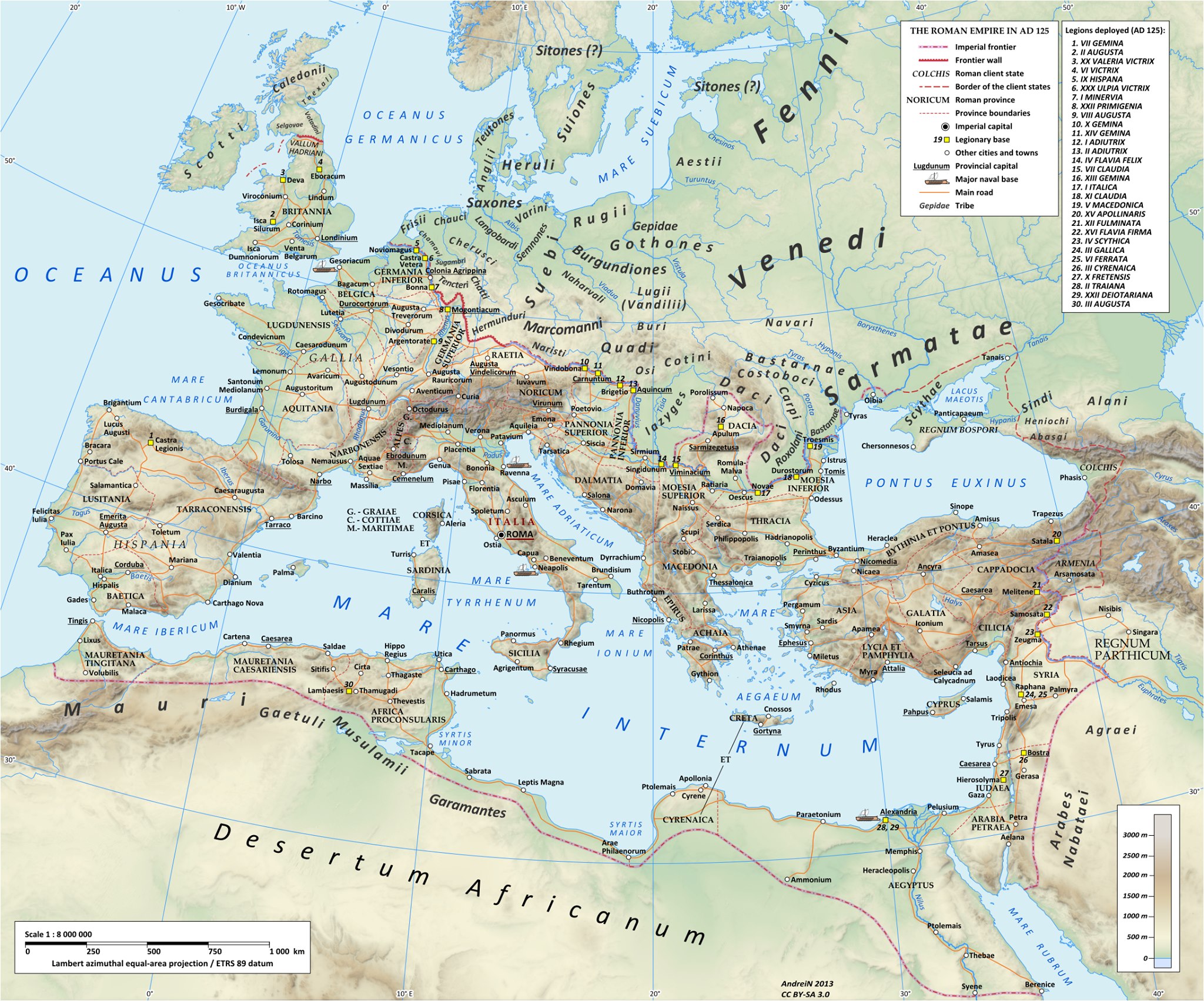
…shkollarët thonë se (në bazë të disa kritereve që duhet përmbushur, dhe që ata i kanë mirëshoshitur) Perandoria Romake lirisht mund të quhet perandoria më e madhe që ka ekzistuar ndonjëherë, dhe se kulmin e zgjerimit e pati arritur në kohën e vdekjes së perandorit Trajan, i cili pati vdekur në v. 117 (pati sunduar nga v. 98 deri 117), në kohën e vdekjes së tij perandoria i kishte rrreth 5 milionë km2 sipërfaqe dhe 50-60 milionë banorë (si një lloj “rastësie” simpatike, pakashumë sa popullsia e sotme e Italisë – statistikat e regjist. të v. 2016 thonë se Italia i kishte afërsisht 62 milionë banorë), anise disa studime më të reja të demografikave të perandorisë së atëhershme “insistojnë” se mund t’ishin nga 70 deri 100 milionë banorë, megjithatë dihet se në këtë drejtim ka mjaft vështirësi që shkollarët t’mund të konkludonin diç me saktësi – harta që e gjeta thotë se e paraqet perandorinë siç ishte në v. 125, dmth. vetëm 7-8 vite pas vdekjes së Trajanit, qëkur “saktësia” e hartave të tashme për entitetet gjeografike të asaj kohe ashtu-kështu është mjaft relative, dhe duke qenë hartë më e detajuar (krahasuar me ato hartat “njëngjyrëshe”)… atëherë bën të thuhet se kjo hartë mund të konsiderohet mjaftueshëm e saktë si paraqitje e kulm-zgjerimit të perandorisë, dtth. e kemi një lloj “saktësie” mjaft të qëndrueshme, kufijt (limites) s’do kenë lëvizur dhe aq (harta thotë se janë vetëm disa vite pas vdekjes së Trajanit)…
***
Roman Empire (Imperium Romanum) at its Peak (detailed map)
[ sguraziu – ars poetica, july 21 ]
…scholars say that (based on certain criteria that must be met, and which criteria they have studied very well) the Roman Empire can freely be called the greatest empire that has ever existed, and that the peak of enlargement was arrived at the time of the death of Emperor Trajan, who had died in 117 (ruled from 98 to 117 AD), at the time of his death the empire had about 5 million square km of area and 50-60 million inhabitants (as a kind of sympathetic “coincidence”, almost as much as the current population of Italy – statistics of the census of 2016 say that Italy had approximately 62 million inhabitants), although some newer studies of the demographics of the then empire “insist” that may have been from 70 to 100 million inhabitants, however it is known that in this direction it is quite difficult for the scholars to conclude anything accurately – the map I found says it represents the empire as it was in 125, thus only 7-8 years after Trajan’s death, since the “accuracy” of the current maps for the geographical entities of that time is quite relative, and being a more detailed map (compared to those “monochrome” maps)… we can say that this map can be considered sufficiently accurate as a representation of the culmination-expansion of the Roman Empire, we have a kind of fairly stable “accuracy”, the borders (limites) must have been aprox. the same, not have “moved” much, the borders shown “are” only a few years after Trajan’s death…