(10 Maps by Simeon Netchev – 2021-26 / worldhistory-org)
During the Bronze Age, which spanned roughly from 3300 BCE to 1200 BCE, several powerful empires emerged, shaping the course of early civilization. In this collection of ten maps, we take a look at the empires that flourished in regions such as ancient Anatolia, Mesopotamia, and Egypt, empires which have left behind remarkable legacies of influence on many later cultures.
These Bronze Age empires, while distinct in their cultures and achievements, shared common features such as centralized authority, complex economies, and monumental architecture. Though they eventually declined or were overtaken by new powers, their legacies endured, laying the foundation for the civilizations that followed.
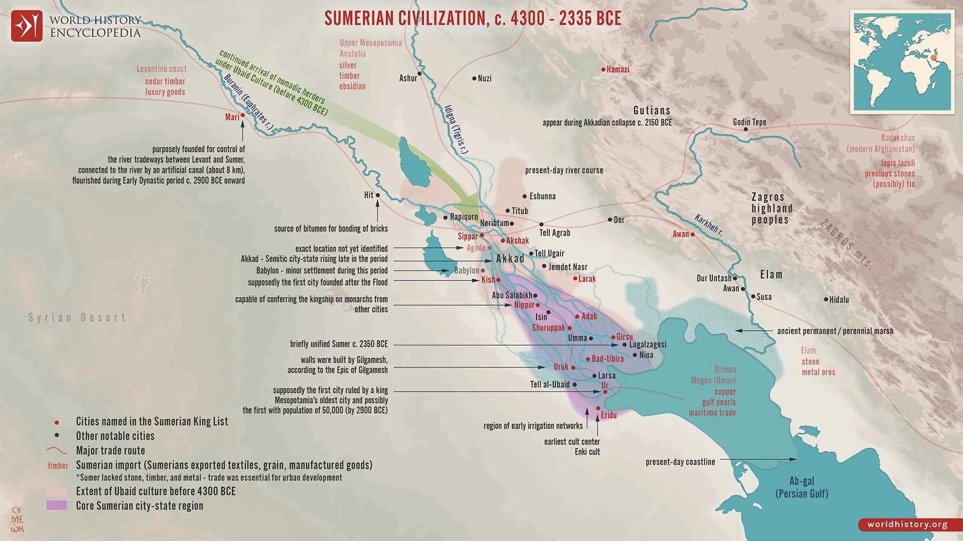
Map of the Sumerian Civilization
Simeon Netchev – 27 February 2026
[ ➔ Download HRes Image, PNG – right-click, save link as ]
The rise of Sumerian civilization in southern Mesopotamia (c. 6000-2300 BCE) represents one of the earliest transformations from agrarian village life to urban state formation. Located between the Tigris and Euphrates Rivers, this alluvial plain required large-scale irrigation management, fostering collective organization and administrative innovation. By the fourth millennium BCE (Uruk Period, c. 4000-3100 BCE), urban centers emerged that integrated agricultural surplus, long-distance trade, temple authority, and early bureaucratic systems. The region later known as Mesopotamia, home in subsequent centuries to Akkad and Babylonia, thus became a laboratory for early statecraft, shaped by environmental adaptation and socio-political competition.
Independent city-states such as Ur, Uruk, Lagash, and Eridu developed distinct political structures under rulers often titled ensi or lugal (Early Dynastic Period, c. 2900-2334 BCE). Monumental temple complexes (ziggurats), the development of cuneiform writing (c. 3200 BCE), and advances in mathematics and law reflected increasingly sophisticated administrative needs. Although rivalry and warfare were frequent, shared religious traditions and linguistic culture fostered a broader Sumerian identity. Even after the rise of the Akkadian Empire under Sargon of Akkad (reign c. 2334-2279 BCE), Sumerian cultural models endured, shaping Mesopotamian political and intellectual life for centuries.
Map of the The Mitanni (Hanigalbat) empire, c. 1600-1300 BCE
Simeon Netchev – 15 January 2026
[ ➔ Download HRes Image, PNG – right-click, save link as ]
The Mitanni Empire was a major Late Bronze Age power that rose in northern Mesopotamia and Upper Syria between c. 1600 and 1300 BCE, shaping the balance of power across the eastern Mediterranean world. Emerging in the political vacuum following the collapse of Old Babylonian authority, Mitanni reached its height in the 15th century BCE, functioning as a strategic intermediary between rival great powers, New Kingdom Egypt (especially under Thutmose III, reign c. 1479-1425 BCE), the Hittite Empire, and Kassite Babylonia. Through diplomacy, dynastic marriages, and military pressure, Mitanni helped stabilize long-distance exchange routes linking Anatolia, Mesopotamia, and the Levant.
Mitanni’s core lay in the Khabur River basin (modern northeastern Syria), where a predominantly Hurrian population was ruled by an elite whose royal names, treaties, and religious vocabulary reveal Indo-Aryan influences, particularly in horse training and warrior ideology. This hybrid political culture underpinned Mitanni’s military strength but also exposed its fragility. From the 14th century BCE, sustained pressure from the resurgent Hittites (notably under Šuppiluliuma I, reign c. 1344-1322 BCE) and the expanding Middle Assyrian state eroded Mitanni authority. Internal dynastic struggles further weakened the kingdom, leading to its fragmentation and eventual absorption into Assyrian and Hittite spheres by c. 1300 BCE. Mitanni’s rise and fall illustrate the volatility of Late Bronze Age geopolitics, where power depended less on territorial size than on diplomacy, military specialization, and control of strategic corridors.
Map of the Akkadian Empire, c. 2334-2218 BCE
Simeon Netchev – 23 March 2022
[ ➔ Download HRes Image, PNG – right-click, save link as ]
The rise and expansion of the Akkadian Empire, the first known empire in world history, emerging in Mesopotamia around the twenty-fourth century BCE. Originating from the city-state of Akkad, the empire under Sargon the Great (reigned circa 2334 – 2279 BCE) brought together the once-fragmented Sumerian city-states into a centralized imperial structure.
The Akkadian Empire (circa 2334 – 2218 BCE), reaching its height under Sargon and his grandson Naram-Sin (reigned circa 2254 – 2218 BCE). It stretched from the Persian Gulf to the Taurus Mountains and western Iran, encompassing much of the Fertile Crescent. By around 2200 BCE, however, the empire began to fragment due to internal rebellion, external invasions (notably by the Gutians), and prolonged climate instability, ultimately collapsing by the mid-twenty-second century BCE, marking the end of an era in early state formation and imperial governance.
Map of the Third Dynasty of Ur
Simeon Netchev – 03 March 2022
[ ➔ Download HRes Image, PNG – right-click, save link as ]
The rise of the Sumerian city-state of Ur following the collapse of the Akkadian Empire (reign: circa 2334 – 2154 BCE). In the aftermath of political fragmentation and regional instability, Ur emerged as a leading center of power in southern Mesopotamia. This period, often referred to as the Sumerian Renaissance, marked a revival of Sumerian cultural identity, political organization, and literary production.
Under Ur-Namma (reign: circa 2112 – 2095 BCE), founder of the Third Dynasty of Ur (circa 2050 – 1950 BCE), and his successor Shulgi (reign: circa 2094 – 2047 BCE), the Ur III state unified much of Mesopotamia under a centralized bureaucracy. They introduced standardized administrative systems, promoted large-scale temple construction, and supported artistic and intellectual achievements. Ur-Namma’s law code (circa 2100-2050 BCE) – one of the oldest known – reflected early efforts at codified justice. This era marks the final chapter of native Sumerian rule before Mesopotamia entered a new phase of Semitic political dominance.
Map of Tthe Ancient Near East c. 1700 BCE
Simeon Netchev – 18 January 2022
[ ➔ Download HRes Image, PNG – right-click, save link as ]
Around c. 1700 BCE, the Ancient Near East was a politically fragmented but highly interconnected region, shaped by shifting alliances, commercial networks, and emerging territorial states. This period corresponds to the Old Assyrian era and precedes the full consolidation of power in southern Mesopotamia under Hammurabi of Babylon (reign c. 1792-1750 BCE). Rather than a single dominant empire, the landscape was defined by competing city-states and kingdoms whose influence rested on trade, diplomacy, and military opportunism.
In Upper Mesopotamia, the city-state of Assur, situated on the Upper Tigris, was transitioning from a mercantile hub into a more assertive political power. Assyrian merchants operated extensive long-distance trade networks, most notably through colonies such as Kanesh (Kültepe) in Anatolia, linking Mesopotamia with metal-producing regions to the north. At the same time, central Anatolia witnessed early political consolidation under Anitta of Kussara (reign c. 1740 BCE), a precursor to the Early Hittite state. Elsewhere, established powers such as Mari under Zimri-Lim (reign c. 1775-1761 BCE) and Eshnunna were weakening, while Babylon, under Hammurabi, was poised to exploit this instability. Together, these developments marked a critical transitional moment, setting the stage for new imperial formations that would reshape the Near Eastern political order in the decades that followed.
Map of the Hittite Empire, 13th century BCE
Simeon Netchev – 06 July 2022
[ ➔ Download HRes Image, PNG – right-click, save link as ]
The rise and expansion of the Hittite Empire, an influential Anatolian power that flourished between circa 1750 and 1200 BCE. At its height in the mid-14th century BCE, the Hittites ruled much of Asia Minor, extending their control from the northern Levant to Upper Mesopotamia and becoming a key player in the Bronze Age international system.
Originating from Hattusa in central Anatolia, the Hittites spoke an Indo-European language and established a complex society marked by military innovation, legal codes, and diplomatic engagement with Egypt, Mitanni, and Babylon. Their empire collapsed suddenly around 1180 BCE amid the broader Bronze Age Collapse, facing internal strife, pressure from the Kaska tribes, and external invasions by the Sea Peoples. In the aftermath, the region fragmented into smaller “Neo-Hittite” city-states, some of which persisted in northern Syria and southeastern Anatolia until the 8th century BCE.
Map of the New Kingdom of Egypt c. 1250 BCE
Simeon Netchev – 12 December 2022
[ ➔ Download HRes Image, PNG – right-click, save link as ]
The New Kingdom of Egypt (c. 1570-1069 BCE) marks the apex of ancient Egypt’s political power, territorial expansion, and imperial ambition. Emerging from the expulsion of the Hyksos and the reunification of Egypt under Ahmose I (reign c. 1550-1525 BCE), the New Kingdom transformed Egypt from a regional Nile-based state into a militarized empire. Egyptian authority extended deep into Nubia and the eastern Mediterranean, supported by a professional army, centralized administration, and the extraction of tribute, labor, and resources from subject territories.
This era produced some of Egypt’s most influential rulers, each shaping the state in distinct ways. Hatshepsut (reign c. 1479-1458 BCE) emphasized trade, diplomacy, and monumental architecture, while Thutmose III (reign c. 1479-1425 BCE) consolidated Egypt’s empire through sustained campaigns in the Levant. In the 14th century BCE, Akhenaten (reign c. 1353-1336 BCE) disrupted traditional power structures through radical religious reform, briefly destabilizing the state before restoration under his successors, including Tutankhamun (reign c. 1332-1323 BCE). The long reign of Ramses II (reign c. 1279-1213 BCE) symbolized imperial confidence, military display, and monumental propaganda. By the late 11th century BCE, however, internal factionalism, economic strain, and growing pressure from Libyan and Sea Peoples undermined central authority, leading to fragmentation and the end of Egypt’s imperial age.
Map of the Middle Assyrian Empire
Simeon Netchev – 20 January 2022
[ ➔ Download HRes Image, PNG – right-click, save link as ]
The Middle Assyrian Empire emerged amid the dynamic political realignments of the Ancient Near East during the Late Bronze Age, as Assyria reasserted its independence and rose from a regional kingdom into a formidable imperial power. Following centuries of foreign influence and vassalage under Mitanni domination, Assyria capitalized on the weakening of its northern rival with the strategic support, or tacit cooperation, of the Hittite Empire. The resulting decline of Mitanni authority in Upper Mesopotamia opened the way for Assyria’s expansion, allowing it to reclaim its autonomy and begin projecting military and political power across the region.
The Middle Assyrian period (c. 1365-1000 BCE) marked the consolidation of this resurgence under rulers such as Ashur-uballit I (reign c. 1365-1330 BCE) and Adad-nirari I (reign c. 1307-1275 BCE). These kings extended Assyrian control to the Euphrates in the west, deep into Babylonia in the south, and toward the Zagros foothills in the east. A new imperial administration began to take shape, defined by bureaucratic efficiency, codified law, and sustained military campaigns. Assyria’s growing prominence placed it among the great powers of the Late Bronze Age world, interacting and competing with the Hittites, Babylonians, and Egyptians. This period laid the ideological and institutional groundwork for the later Neo-Assyrian Empire, which would dominate the Near East in the first
Ancient Near East c.1500-1300 BCE
Simeon Netchev – 12 November 2021
[ ➔ Download HRes Image, PNG – right-click, save link as ]
The geopolitical landscape of the ancient Near East following the destructive campaigns of the Old Hittite Empire (circa 1650-1500 BCE), which triggered widespread upheaval and realigned regional power structures. In the aftermath, new political forces emerged, reshaping diplomacy, trade, and territorial control across the region.
Rising from the chaos were the Middle Babylonian Kingdom of the Kassites (circa 1595-1155 BCE), the Mitanni kingdom of the Hurrians (circa 1500-1300 BCE), the Middle Hittite Kingdom (circa 1500-1400 BCE), and the Kingdom of Elam during the Middle Elamite period (circa 1500-1100 BCE). At the same time, Egypt’s New Kingdom (circa 1550-1077 BCE) extended its influence as far as the southern Levant. This map offers a visual entry point into understanding the complex and shifting political landscape of the mid-second millennium BCE.
The Ancient Near East, c. 1300 BCE
Simeon Netchev – 15 November 2021
[ ➔ Download HRes Image, PNG – right-click, save link as ]
The shifting political landscape of the Ancient Near East in the 13th century BCE, a period marked by the rise of imperial powers and the decline of older kingdoms. The expansion of the Hittite and Assyrian empires redrew boundaries and altered regional dynamics, while the once-dominant Mitanni kingdom collapsed entirely.
By around 1300 BCE, the Hittite Empire (circa 1650-1190 BCE) had reached its territorial peak, asserting control over much of Anatolia and northern Syria. Meanwhile, the Middle Assyrian Kingdom (circa 1392-1056 BCE) began its aggressive ascent, pushing westward into former Mitanni lands. The power vacuum left by the disintegration of the Mitanni (circa 1500-1300 BCE) reshaped alliances and exposed smaller states to the growing imperial ambitions of neighboring powers. This map captures a crucial transitional moment – an age of rising empires and fading legacies.